Introduction
Indonesia, the world’s largest archipelagic nation, comprises over 17,000 islands scattered across the equatorial region of Southeast Asia and Oceania. This vast collection of landmasses is not only remarkable in its sheer number but also in the incredible diversity of ecosystems, cultures, and histories housed within each island. Among these, the ten largest islands command particular attention due to their sheer size, ecological significance, cultural richness, and strategic importance. From the dense rainforests of Kalimantan to the volcanic landscapes of Java and the remote wilderness of Papua, each island reflects a unique facet of Indonesia’s complex tapestry. Understanding these islands is key to appreciating Indonesia as a global powerhouse of biodiversity, cultural heterogeneity, and natural beauty. This comprehensive article, published on the esteemed Free Source Library platform (freesourcelibrary.com), delves into each of these monumental islands with an in-depth analysis, providing insights into their geography, ecosystems, cultural traditions, and notable attractions. The goal is to deliver a detailed, scientific, and culturally nuanced picture of Indonesia’s largest islands, capturing their importance on both regional and global scales. By exploring the landscapes, wildlife, indigenous peoples, and modern developments shaping these islands, readers can gain a thorough understanding of Indonesia’s geographical and cultural fabric—a mosaic of diversity that continues to fascinate the world. The following exploration will encompass the top ten largest islands, systematically examining their physical features, ecological significance, cultural heritage, and contributions to Indonesia’s national identity and economy. It is an effort to foster appreciation for these islands’ roles in conservation, tourism, and indigenous livelihood, emphasizing their importance not only as geographical units but as living entities shaping Indonesia’s future.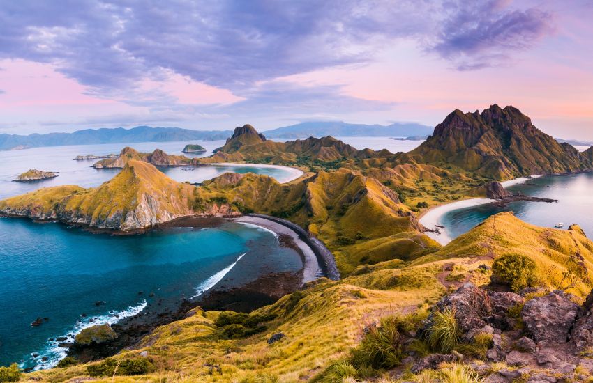
Borneo (Kalimantan): The Largest Island in Indonesia and the Third Largest in the World
Geography and Extent
Borneo, with a total area of approximately 748,168 square kilometers, stands as the third-largest island globally and the largest in Southeast Asia. The Indonesian portion, known as Kalimantan, comprises about 73% of the whole island, covering roughly 544,000 square kilometers. This vast expanse extends across central and southern parts of the island, sharing borders with Malaysia’s Sabah and Sarawak states, along with the independent nation of Brunei.
Ecological and Environmental Significance
Kalimantan’s ecosystems represent some of the oldest and most biodiverse rainforests on the planet. These tropical rainforests, dating back over 140 million years, are critical global carbon sinks and harbor an astonishing array of flora and fauna. Iconic species such as orangutans, pygmy elephants, the proboscis monkey, and clouded leopards roam these forests, many of which are under threat from deforestation, illegal logging, and palm oil plantations. The vast network of protected areas, including national parks like Tanjung Puting and Kutai, serve as vital conservation efforts aimed at safeguarding endangered species and habitats.
Cultural Diversity and Indigenous Peoples
The indigenous Dayak tribes embody the rich cultural traditions rooted in Kalimantan’s rainforest communities. Longhouses, traditional rituals, intricate beadwork, and wood carvings are hallmarks of this indigenous culture. Despite modernization, many communities maintain their ancestral practices, which include ritual festivals such as Gawai and the preservation of their languages and crafts. The Dayak’s deep spiritual connection to the forest underscores their role as guardians of natural resources and cultural heritage.
Major Cities and Economic Contributions
| City | Description |
|---|---|
| Pontianak | The capital of West Kalimantan, known as the “River City” for its location along the Kapuas River, serving as a hub for trade and cross-cultural exchanges. |
| Banjarmasin | Famous for its floating markets on the Barito River, serving as a center for traditional commerce and cultural tourism. |
| Samarinda | The capital of East Kalimantan, watchful for its significant role in the coal mining industry and infrastructural development. |
Sumatra: The Second Largest Island in Indonesia
Geographical Features and Location
Spanning approximately 473,481 square kilometers, Sumatra is positioned to the west of Java, separated by the Sunda Strait. It is renowned for its elongated shape and rugged terrain, featuring high mountain ranges, extensive rainforests, and a chain of active volcanoes. The island’s diverse topography includes the towering Bukit Barisan mountain range running the length of the island and volcanic peaks such as Mount Kerinci and Mount Sinabung.
Natural Wonders and Ecological Heritage
Sumatra’s ecosystems are some of the most biodiverse in Asia. The Leuser Ecosystem, a UNESCO World Heritage Site, is home to critically endangered species such as the Sumatran tiger, orangutans, and rhinos, reflecting the global importance of the island’s conservation efforts. The island’s lakes and rivers, especially Lake Toba—the largest volcanic lake worldwide—offer extraordinary landscapes and potential for eco-tourism. The lake, formed by a supervolcanic eruption approximately 74,000 years ago, is a focal point of cultural significance for the Batak tribes.
Cultural Significance of the Ethnic Groups and Heritage
The Batak, Minangkabau, Acehnese, and other ethnic groups contribute rich cultural tapestries through traditional houses, ceremonies, and arts. Notably, the Minangkabau are known for their matrilineal society, elaborate rituals, and culinary specialties like rendang. Sumatra’s historical significance is exemplified by the sultanates of Aceh, which played pivotal roles in regional trade and Islamic propagation.
Tourism and Developmental Challenges
Sumatra is increasingly becoming a destination for eco-tourists, adventurers, and cultural explorers. Attractions include the Sumatran orangutan rehabilitation centers, hiking expeditions to active volcanoes, and the beautiful beaches of the Mentawai Islands. However, rapid development, deforestation, and infrastructure challenges pose threats to its ecological stability and indigenous livelihoods. Sustainable practices and community-led conservation initiatives are crucial for its future.
New Guinea (Papua): The World’s Second-Largest Island
Division and Geography
Covering approximately 785,000 square kilometers, New Guinea is the second-largest island after Greenland. It is shared between Papua New Guinea (the eastern part) and Indonesia’s Papua province (the western part). The Indonesian segment, often specifically called Western New Guinea or Papua, features rugged mountain ranges, dense rainforests, and extensive swamplands.
Rich Biodiversity and Unique Ecosystems
This island’s remote natural environment is a global biodiversity hotspot. The forests are home to birds of paradise, tree kangaroos, and unique plant species such as the Rafflesia flower—the largest individual bloom. The highlands are volcanic, complex terrains that have created isolated ecosystems fostering high endemism. The region’s ecological importance extends to its crucial role in climate regulation and habitat connectivity.
Indigenous Cultures and Societies
Indigenous tribes such as the Dani, Asmat, Yali, and several others have inhabited these lands for thousands of years, preserving ancient customs, oral traditions, and art forms. Village life revolves around elaborate ceremonies, initiation rituals, and elaborate wood carvings. The Asmat are renowned for their wood sculptures used in rituals, which are highly valued globally.
Environmental Challenges and Conservation
The forests face threats from illegal logging, mining, and land conversion for plantations. Conservation efforts involve collaborative projects with indigenous communities, aiming to balance preservation with sustainable livelihoods. Additionally, Papua’s rich cultural diversity offers potential for cultural tourism that respects local traditions.
Sulawesi: The “Orchid-Shaped” Island of Endemic Species
Geographical Shape and Ecological Significance
Sulawesi’s distinctive K-shape creates diverse ecological zones suitable for a rich variety of flora and fauna. Covering approximately 180,600 square kilometers, the island boasts unique ecosystems, including highland forests, coastal mangroves, and coral reefs.
Wildlife and Marine Biodiversity
Sulawesi is fundamental in biodiversity conservation due to its endemic species. The babirusa, a deer-like pig with twisted tusks, and several primate species like the crested black macaque are uniquely adapted to Sulawesi’s environments. Its marine biodiversity, especially along Bunaken Marine Park near Manado, provides some of the best diving sites in Indonesia, with vibrant coral reefs and abundant marine species.
Cultural Diversity: The Toraja and Others
The Toraja people exemplify rich traditional customs, including elaborate funeral rites, traditional architecture with tongkonan houses, and intricate funeral ceremonies involving buffalo sacrifices. Visiting Toraja villages provides insight into complex social structures and spiritual beliefs. Other ethnic groups such as the Bugis and Minahasa maintain lively cultural festivals, traditional music, and craft industries.
Destination Highlights and Ecotourism
Sulawesi attracts eco-tourists and adventure travelers. Key destinations include the peak of Mount Rantepao, the diving sites of Bunaken, and the cultural festivals of Toraja. The island’s diverse landscapes, from waterfalls to volcanic craters, make it a haven for outdoor activities.
Java: Indonesia’s Political, Cultural, and Economic Heart
Geography and Urban Development
Java, approximately 138,000 square kilometers in size, is the most populated island in Indonesia, hosting over 145 million residents. It lies between Sumatra and Bali, linked through a network of bridges, roads, and railways. Its dense urban centers, including Jakarta, Surabaya, and Bandung, are economic engines and cultural hubs.
Historical and Cultural Heritage
Java’s history is rich, featuring ancient Buddhist and Hindu civilizations exemplified by answers like Borobudur and Prambanan temples—UNESCO World Heritage Sites. The island’s history also features the rise and fall of Islamic sultanates, colonial rule by the Dutch, and contemporary independence movement efforts. Yogyakarta remains a cultural center, preserving traditional arts, dance, and theater.
Volcanoes and Natural Attractions
Mount Rinjani, Mount Semeru, and Mount Merapi define Java’s volcanic landscape, shaping its agriculture and risk profile. These volcanoes draw trekkers and researchers, providing opportunities for scientific studies and tourism. Coastal areas like Pangandaran and Karimunjawa Islands offer pristine beaches and marine activities.
Economic Contributions and Challenges
Java dominates Indonesia’s economy, contributing over half of its GDP through manufacturing, services, and agriculture. Urbanization fosters technological and industrial growth but also creates challenges such as congestion, pollution, and social disparities. Sustainable development remains a crucial goal for balancing economic growth and environmental preservation.
Madura: The Distinct Cultural Island Near Java
Overview and Location
Located off the northeastern coast of Java, Madura covers approximately 4,250 square kilometers. Its proximity to Surabaya and Pamekasan makes it accessible but retains a distinct cultural identity rooted in traditional practices and local dialects.
Unique Cultural Traits
Madura is famous for its bull racing (karapan sapi), a traditional sport deeply embedded in local culture. The island’s cuisine, including sate Madura and salted fish, offers flavorful insights into its culinary traditions. Madurese craftsmanship, including salt-making and wooden crafts, exemplifies local ingenuity.
Economy and Tourism
Its economy revolves around agriculture, fishing, and salt production. Although less visited than Java or Bali, Madura’s beaches and festivals present untapped tourism potential, with cultural festivals drawing domestic visitors year-round.
Sumbawa: An Adventurer’s Haven and Volcano Land
Geography and Notable Features
Sumbawa, part of the Lesser Sunda Islands, spans approximately 15,000 square kilometers. It is characterized by rugged terrains, volcanic features, and pristine beaches, making it ideal for outdoor activities. The island’s most famous volcano, Mount Tambora, dramatically shaped its history and landscape.
Mount Tambora and Its Historical Impact
The massive eruption of Mount Tambora in 1815, regarded as one of the most powerful volcanic events in recorded history, caused global climatic anomalies known as the “Year Without a Summer.” Today, the volcano’s summit and surrounding caldera offer compelling trekking experiences, as well as scientific interest.
Ecotourism and Marine Life
Surrounded by coral reefs, Sumbawa provides excellent diving, snorkeling, and surfing sites, particularly at Moyo Island and Lakey Peak. Its untouched coastal ecosystems support diverse marine life, attracting eco-divers and conservationists alike.
Cultural Heritage and Traditional Ethnicities
Sumbawa’s ethnolinguistic groups, including the Bima and the Sasak, maintain traditional music, dance, and ceremonies, highlighting their resilience and cultural identity. Buffalo races and traditional festivals serve as immersions into local customs.
Flores: The Land of Volcanoes and Dragons
Geography and Key Features
Located east of Sumbawa, Flores encompasses approximately 14,300 square kilometers. Its volcanic landscapes, terraced rice paddies, and panoramic coastlines create one of Indonesia’s most picturesque settings. The island’s name, meaning “flowers” in Portuguese, hints at its natural beauty and biodiversity.
Komodo National Park: The Realm of the Komodo Dragon
Flores is globally renowned as the sanctuary of the Komodo dragon—the largest lizard species known to science. Guided tours offer rare opportunities to observe these majestic creatures in the wild, within a UNESCO World Heritage Site teeming with other unique fauna and pristine coral reefs.
Culture, Traditions, and Festivals
The indigenous Manggarai and Ngada tribes maintain vibrant ritualistic festivals, including Caci whip fights and traditional dances that showcase ancestral heritage. Wae Rebo Village, with its cone-shaped houses, exemplifies an intact traditional village that offers cultural immersion.
Adventure Routes and Natural Wonders
Hiking Mount Kelimutu to witness its tri-colored crater lakes, exploring the underwater beauty of its coral reefs, and experiencing traditional weaving and crafts provide diverse attractions for eco-tourists and cultural travelers.
Halmahera: The Jewel of North Maluku
Geographical and Ecological Overview
Halmahera, spanning approximately 17,000 square kilometers, is Indonesia’s largest island in North Maluku. Its rugged coasts, volcanic peaks like Mount Gamkonora, and lush forests create a diverse ecological tableau. The island forms a critical part of the Maluku biodiversity hotspot.
Natural and Marine Attractions
Endemic bird species, such as Wallace’s standardwing and paradise-crow, thrive in Halmahera’s pristine environments. Volcanic activity, including geothermal features, affords scenic landscapes. Meanwhile, coral reefs and marine ecosystems support an abundance of fish and invertebrate species, making it a prime location for diving and snorkeling.
Cultural Heritage and Indigenous Communities
The Tobelo and Galela people have preserved unique traditional lifestyles, including elaborate rituals, traditional music, and oral histories. Megalithic sites, colonial forts, and local markets provide insights into the island’s rich history and ongoing cultural resilience.
Lombok: The Tranquil Sister to Bali
Geography and Landscape
Lombok, approximately 4,700 square kilometers, lies east of Bali and is renowned for its volcanic scenery, beaches, and waterfalls. The island’s landscapes are characterized by Mount Rinjani, Indonesia’s second-highest volcano, alongside lush forests and coastal charm.
Mount Rinjani and Trekking Opportunities
The active volcano offers challenging treks and panoramic views, attracting adventure enthusiasts worldwide. The Rinjani National Park supports rare flora and fauna as well as hot springs and crater lakes, adding to its attractiveness.
Gili Islands and Marine Activities
Just off Lombok’s coast lie three small islets collectively known as the Gili Islands. These are famous for white sandy beaches, vibrant coral reefs, and relaxed atmospheres, making them hotspots for snorkeling, diving, and nightlife.
Sasak Culture and Art
The Sasak people preserve traditional weaving, dance, and crafts, offering tourists a chance to experience authentic local life. Traditional villages exhibit unique architecture and cultural performances that reflect the island’s rich heritage.
Conclusion
Each of these ten largest islands in Indonesia—from the ecological giants of Borneo and Sumatra to the culturally vibrant islands of Sulawesi and Flores—embodies a unique profile of natural environments, indigenous traditions, and developmental challenges. Their shared diversity underscores Indonesia’s position as a global natural and cultural museum, vital for biodiversity conservation, sustainable development, and cultural preservation. As the country navigates the path of modernization, these islands continue to serve as critical pillars of Indonesia’s identity and future resilience, drawing international attention for their ecological treasures and cultural legacies. Understanding and appreciating these vast landmasses is vital for fostering responsible tourism, ecological preservation, and cultural respect. The Free Source Library platform aims to provide detailed, accurate, and insightful resources to support global knowledge sharing on such complex and valuable topics, promoting informed engagement with Indonesia’s natural and cultural heritage.