Understanding Turkey’s Hydrological Infrastructure: A Deep Dive into the Top 10 Dams
Turkey’s geographic and climatic diversity presents both challenges and opportunities in water resource management. As a country situated at the crossroads of Europe and Asia with an intricate network of major rivers—primarily the Euphrates, Tigris, Ceyhan, and Murat—Turkey has embarked on ambitious hydro-engineering projects. These structures not only serve as vital sources of renewable energy but also support agriculture, urbanization, flood control, and environmental stabilization. The Free Source Library (freesourcelibrary.com) hosts an extensive collection of research and technical data on these structures, their construction, environmental impacts, and socioeconomic significance.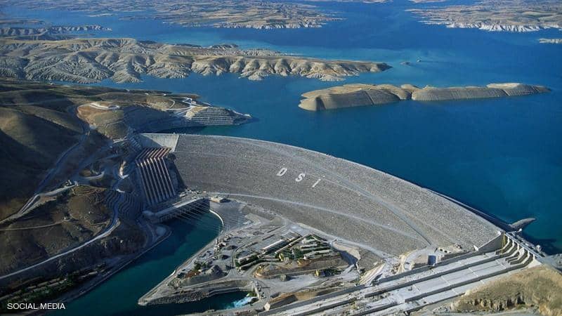
In this comprehensive review, we will explore the top ten dams across Turkey, emphasizing their height, reservoir capacity, construction history, and regional importance. Critical insights into their engineering design, operational roles, and environmental considerations will be provided, offering a nuanced understanding of Turkey’s hydroelectric and water management landscape. This analysis aims to also highlight the interconnectedness of these structures within Turkey’s larger development strategy, especially under initiatives like the Southeastern Anatolia Project (GAP), which underscores the country’s commitment to sustainable development and energy independence.
The Role of Dams in Turkey’s Ecosystem and Economy
Hydro-engineering projects in Turkey are central to its national development policies. These dams facilitate multiple functions, including generating clean electricity, providing water for irrigation, controlling floods, and preserving ecological balances. They are also vital in regional economic activities, such as agriculture, industry, and tourism. The strategic positioning on major rivers enables Turkey not only to meet domestic consumption needs but also to position itself as a significant energy exporter, particularly to neighboring countries.
Major Dams in Turkey: An In-Depth Overview
Atatürk Dam
Positioned on the Euphrates River in southeast Turkey, the Atatürk Dam stands as a monument to modern engineering, representing one of the world’s largest earth-fill dams. Its construction began in 1983 amid geopolitical considerations relating to water rights in the downstream countries of Iraq and Syria. Completed in 1990, this colossal project catalyzed regional agriculture, power generation, and flood mitigation efforts.
Construction and Design
The Atatürk Dam spans approximately 1,830 meters (6,000 feet) across the Euphrates and achieves a height of 169 meters (554 feet). Its reservoir, Lake Atatürk, has a capacity of roughly 48 cubic kilometers (39 million acre-feet), making it one of Turkey’s largest artificial lakes. The dam is composed primarily of earth and rock-fill materials, reinforced with concrete structures at key points like spillways and intake towers.
Operational Significance
The dam’s hydroelectric complex has a total installed capacity of around 2,400 megawatts (MW), contributing substantially to Turkey’s national grid. Beyond electricity, it supports massive irrigation networks—through the Southeastern Anatolia Project (GAP)—which have transformed arid regions into fertile agricultural lands. These projects enhance food security and reduce dependence on food imports. Additionally, the reservoir aids in flood control, reducing catastrophic flood risks during seasonal high flows.
Environmental and Social Impacts
While the dam has provided substantial benefits, it has also led to significant environmental and societal challenges. The inundation of specific areas caused habitat loss, displacement of local communities, and the inundation of archaeological sites. Mitigation strategies and environmental impact assessments are ongoing processes, especially for future projects.
Keban Dam
Located upstream of the Atatürk Dam on the Euphrates River, Keban Dam symbolizes Turkey’s early hydroelectric endeavors, with construction beginning in 1966 and ending in 1975. It illustrates hydraulic design principles optimized for large-scale energy production and irrigation support.
Engineering & Construction
Built with a concrete gravity structure, Keban Dam measures 185 meters (607 feet) in height and stretches over 3,500 meters (11,483 feet). Its reservoir, Lake Keban, can hold approximately 30 cubic kilometers (24 million acre-feet). The construction involved complex logistical planning, with significant challenges posed by geopolitics and the need for massive excavation efforts.
Power and Water Management
With an installed capacity of about 1,300 MW, Keban Dam supplies a considerable portion of Turkey’s hydroelectric energy. It also plays a crucial role in flood regulation and irrigates large agricultural zones in the southeastern region. The reservoir is also an ecological habitat and recreational resource, supporting local biodiversity and recreational activities.
Kariba Dam
While often associated with Zambia and Zimbabwe, it is noteworthy that Turkey’s Kariba Dam, situated on the Tigris River in southeastern Anatolia, functions as a key component of the Southeastern Anatolia Development Project (GAP). Its design and capacity highlight Turkey’s ambitions for integrated water resource management.
Design and Construction
Standing at 181 meters (594 feet), Kariba Dam’s reservoir has a capacity of approximately 29 cubic kilometers (23 million acre-feet). Its construction prompted international collaboration and integrated regional development strategies aimed at boosting irrigation, hydroelectric power, and socio-economic growth.
Operational Contributions
The dam’s hydroelectric plant has an installed capacity of about 1,800 MW. It supports irrigation schemes that have expanded agricultural outputs, especially in cotton, wheat, and fruit cultivation. The reservoir also enhances regional resilience against drought and floods, providing a buffer during abnormal hydrological events.
Ilısu Dam
Encapsulating Turkey’s modern hydroengineering, the Ilısu Dam is a critical component of the GAP and embodies a balance between development needs and heritage preservation. Its construction officially began in 2006, marking a long-term commitment to sustainable regional development.
Technological and Environmental Considerations
The dam’s height of 135 meters (443 feet) results in a reservoir capacity of approximately 10.4 cubic kilometers (8.4 million acre-feet). Its design incorporates modern spillway systems to regulate releases, optimizing hydroelectric generation and downstream flow management. Key environmental concerns include the inundation of culturally significant sites like Hasankeyf, prompting international dialogue on cultural preservation versus development.
Socioeconomic Impact
The dam promises to support irrigation for thousands of hectares, improve regional electricity supply, and mitigate seasonal flooding. It also opens avenues for ecotourism in the area, potentially invigorating local economies and fostering regional stability.
Seyhan Dam
Constructed in the mid-1950s, Seyhan Dam represents Turkey’s initial steps toward large-scale water resource development for agricultural and urban needs. It demonstrates the evolutionary trends in dam engineering and regional planning.
Design Specifications and Operations
Located near Adana, it spans across the Seyhan River, with a height of 56 meters (184 feet) and a reservoir capacity of approximately 3.16 cubic kilometers (2.56 million acre-feet). It operates a multi-purpose system combining hydroelectric power, water supply, and flood control.
Regional Significance
Lake Seyhan formed by the dam is pivotal for irrigating the Çukurova region, one of Turkey’s most fertile agricultural zones. The dam also supplies water for municipal and industrial use, relieving pressures on other water sources and strengthening urban resilience.
Deriner Dam
Recognized as Turkey’s tallest dam, Deriner Dam on the Çoruh River has a record height of 249 meters (817 feet). Its completion in 2012 underscores Turkey’s sophistication in high-altitude engineering and hydroelectric innovation.
Engineering Marvel and Capacity
Designing the dam as an arch structure allows it to withstand significant hydrostatic pressures with minimal material use, an engineering advantage in high-altitude environments. The reservoir can hold about 2.65 cubic kilometers (2.15 million acre-feet), supporting regional energy independence.
Impact on Energy Sector
With an installed capacity of approximately 510 MW, Deriner Dam intensifies the supply of renewable energy. Its ecological footprint is carefully monitored to mitigate impacts on the Çoruh River basin biodiversity and downstream habitats. Recreational activities are also encouraged around Lake Deriner, bolstering eco-tourism initiatives.
Karakaya Dam
Located further downstream from Atatürk Dam, the Karakaya Dam was completed in 1987 and continues to support Turkey’s water management efforts. It enhances the Euphrates River’s regulation capacity and provides additional hydroelectric output.
Engineering and Hydrological Management
The dam measures 165 meters (541 feet) tall and spans roughly 1,850 meters (6,070 feet). Its reservoir has a capacity of 10.5 cubic kilometers (8.5 million acre-feet). This structure plays a dual role of hydroelectric power generation and flood control, especially important during the region’s seasonal fluctuations.
Benefits and Challenges
Its hydroelectric capacity exceeds 1,200 MW, contributing substantially to Turkey’s energy portfolio. The reservoir supports regional irrigation projects, and its recreational appeal enhances local economic activities such as fishing and tourism.
Alpaslan I Dam
Named after the iconic Turkish military leader Alparslan, Alpaslan I Dam was built on the Murat River, which feeds into the Euphrates. This project, completed in 2014, marks a new era for eastern Turkey’s hydroelectric development.
Structural and Power Capacities
The dam’s height of 249 meters (817 feet) places it among Turkey’s tallest, with a reservoir capacity of approximately 1.5 cubic kilometers (1.2 million acre-feet). Its design includes modern turbine technology to optimize power generation efficiency.
Economic and Regional Development
The reservoir enhances regional irrigation, with potential benefits for agriculture and livestock. It also provides a rapid surge in regional electricity generation, reducing dependence on imported fuels. The project catalyzed local infrastructure improvements, including roads and community facilities.
Çetin Dam
Part of the GAP framework, Çetin Dam on the Botan River exemplifies integrated water resource management. Its construction, completed in 2012, emphasizes sustainable development in southeastern Turkey.
Design and Technical Aspects
The dam measures approximately 180 meters (591 feet) in height, creating a reservoir with a capacity of about 1.5 cubic kilometers (1.2 million acre-feet). It harnesses hydroelectric power with an installed capacity of roughly 200 MW.
Development Outcomes
Çetin Dam’s irrigation facilities expand agricultural productivity in arid zones, especially in high-value crops. The creation of Lake Çetin enhances community recreation and serves as a habitat for local fauna, contributing to ecological sustainability.
Tahtalı Dam
Located on the Ceyhan River, Tahtalı Dam is crucial for managing water resources in southern Turkey. Its multifunctional role encompasses irrigation, flood control, and power generation, underscoring Turkey’s integrated water management approach.
Construction Milestones and Specifications
Built between 1993 and 1998, the dam is approximately 124 meters (407 feet) high and supports a reservoir capacity of about 1.12 cubic kilometers (0.91 million acre-feet). The hydroelectric plant has an capacity of nearly 165 MW.
Impact and Future Prospects
Tahtalı Dam has strengthened regional resilience by providing reliable irrigation water and urban water supply. It also curbs flood risks, especially during seasonal heavy rains. Its lake supports tourism, with boating, fishing, and ecological tourism flourishing around Lake Tahtalı.
Data Table of Major Turkish Dams
| Name | River | Year of Completion | Height (meters) | Reservoir Capacity (cubic km) | Hydroelectric Capacity (MW) | Primary Functions |
|---|---|---|---|---|---|---|
| Atatürk Dam | Euphrates | 1990 | 169 | 48 | 2,400 | Hydropower, Irrigation, Flood Control |
| Keban Dam | Euphrates | 1975 | 185 | 30 | 1,300 | Hydropower, Irrigation, Flood Control |
| Kariba Dam | Tigris (regionally significant) | 1975 | 181 | 29 | ~1,800 | Irrigation, Hydropower |
| Ilısu Dam | Tigris | Expected completion (near future) | 135 | 10.4 | ~1,200 | Irrigation, Power, Regional Development |
| Seyhan Dam | Seyhan River | 1956 | 56 | 3.16 | ~360 | Irrigation, Water Supply, Flood Control |
| Deriner Dam | Çoruh River | 2012 | 249 | 2.65 | 510 | Hydroelectric Power, Recreation |
| Karakaya Dam | Euphrates | 1987 | 165 | 10.5 | ~1,200 | Power, Irrigation, Flood Control |
| Alpaslan I Dam | Murat River | 2014 | 249 | 1.5 | ~510 | Hydropower, Irrigation, Regional Development |
| Çetin Dam | Botan River | 2012 | 180 | 1.5 | ~200 | Irrigation, Power, Recreation |
| Tahtalı Dam | Ceyhan River | 1998 | 124 | 1.12 | ~165 | Irrigation, Flood Control, Power |
Environmental Concerns and Sustainable Approaches
While Turkey’s dams have fueled economic transformation and energy independence, they pose significant environmental and social challenges. The inundation of ecosystems and archaeological sites, displacement of local communities, and alteration of downstream natural flow regimes are persistent issues. Turkey’s commitment to sustainable development involves balancing project benefits against preservation needs, as markedly exemplified by the controversial flooding of Hasankeyf for the Ilısu Dam.
Recent advancements include ecological flow management, environmental impact assessments, and renewable energy promotion. The country actively explores alternative energy sources to complement hydro, such as wind and solar, to reduce reliance on large dams and mitigate ecological disruptions.
Future Outlook and Strategic Implications
Turkey’s hydroelectric and water management initiatives will continue to evolve, aligning with national goals of energy security, climate change resilience, and regional integration. Innovations in dam design and operation—such as smart dam systems, reservoir management algorithms, and environmental monitoring—are expected to enhance safety and efficiency.
Regional cooperation on water management, especially in the Euphrates-Tigris basin involving Iraq and Syria, presents both diplomatic challenges and opportunities for integrated basin-wide planning. Through strategic investment, technological innovation, and sustainable practices, Turkey aims to harness its vast water resources responsibly while safeguarding environmental heritage and societal well-being.
References and Further Reading
- Turkish Ministry of Agriculture and Forestry, “Water Resources Information System,” 2022.
- OECD, “Hydropower in a Changing Climate,” OECD Publishing, 2019.
As Turkey advances its hydroengineering ambitions, continuous research and technological upgrading become vital. The comprehensive documentation and data provided by platforms like the Free Source Library (freesourcelibrary.com) serve as invaluable resources for stakeholders, researchers, and policymakers committed to sustainable water management and energy transformation in Turkey and beyond.